![](/images/other/stat-length.png)
![Tour Zu Fuß Ballina Municipal District - Drumsheen Loop - Photo](https://media.geolcdn.com/t/1900/400/2a82040a-e8cb-402b-97f0-c725509f5fb5.jpeg&format=pjpeg&maxdim=2)
Drumsheen Loop
SityTrail - itinéraires balisés pédestres
Tous les sentiers balisés d’Europe GUIDE+
![Länge](/images/other/stat-length.png)
Länge
7,7 km
![Maximale Höhe](https://static1.geolcdn.com/siteimages/upload/files/1508320355ic_sort_altitude_max_24dp.png)
Maximale Höhe
233 m
![Positive Höhendifferenz](https://static1.geolcdn.com/siteimages/upload/files/1508320355ic_sort_den_pos_24dp.png)
Positive Höhendifferenz
146 m
![Km-Effort](/images/other/stat-length.png)
Km-Effort
9,7 km
![Min. Höhe](https://static1.geolcdn.com/siteimages/upload/files/1508320355ic_sort_altitude_min_24dp.png)
Min. Höhe
91 m
![Negative Höhendifferenz](https://static1.geolcdn.com/siteimages/upload/files/1508320355ic_sort_den_neg_24dp.png)
Negative Höhendifferenz
142 m
![Boucle](https://static1.geolcdn.com/siteimages/upload/files/16400158638029165_repeat_loop_refresh_sync_direction_icon.png)
Boucle
Ja
Kennzeichnung
Erstellungsdatum :
2025-02-06 12:36:42.049
Letzte Änderung :
2025-02-06 12:36:42.049
![Zu Fuß](https://static1.geolcdn.com/sitytour/trail-icons/100.png)
2h11
Schwierigkeit : Einfach
![Scannen Sie diesen QR-Code, um die Tour in der SityTrail-Anwendung zu öffnen](https://capi.geolives.com/qq0zvz2zws4bq2lad0pu/sitytour/trails/4342878/qr.png?size=200)
Kostenlosegpshiking-Anwendung
Über SityTrail
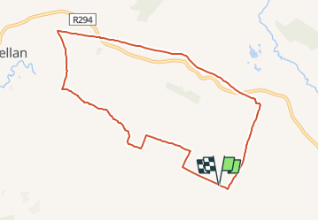
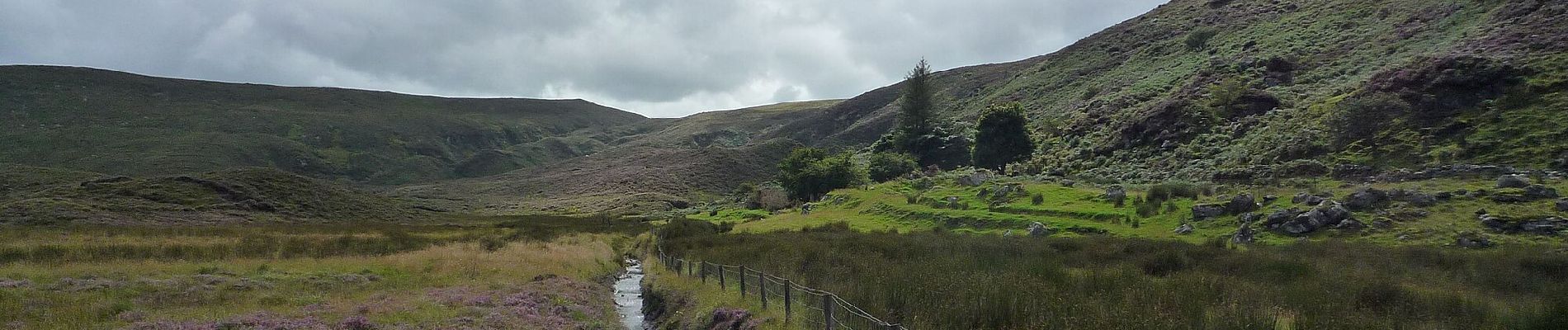
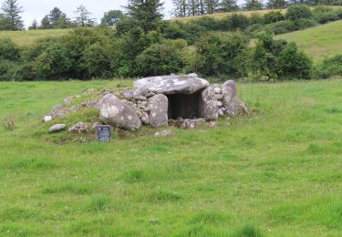
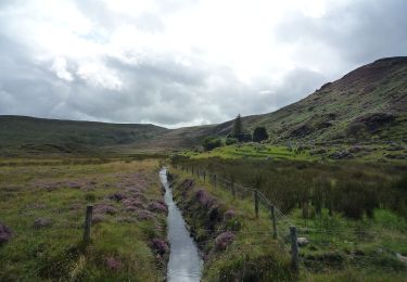
Tour Zu Fuß von 7,7 km verfügbar auf Unbekannt, County Mayo, Ballina Municipal District. Diese Tour wird von SityTrail - itinéraires balisés pédestres vorgeschlagen.
Beschreibung
Sitio web: http://www.mayotrails.ie/bunnyconnellan.html
Ort
Land:
Ireland
Region :
Unbekannt
Abteilung/Provinz :
County Mayo
Kommune :
Ballina Municipal District
Standort:
Kilgarvan ED
Gehen Sie:(Dec)
Gehen Sie:(UTM)
501225 ; 5993947 (29U) N.
Kommentare
Touren in der Umgebung
![Tour Zu Fuß Ballina Municipal District - Bunnyconnellan Loop - Photo](https://media.geolcdn.com/t/375/260/dc12756c-3728-4690-8086-d637a8adc372.jpeg&format=jpg&maxdim=2)
![Zu Fuß Zu Fuß](https://static1.geolcdn.com/sitytour/trail-icons/100.png)
Bunnyconnellan Loop
Zu Fuß
Medium
Ballina Municipal District,
Unbekannt,
County Mayo,
Ireland
![](/images/other/stat-length.png)
20 km | 24 km-effort
5h 23min
![](https://static1.geolcdn.com/siteimages/upload/files/16400158638029165_repeat_loop_refresh_sync_direction_icon.png)
Ja
![Tour Zu Fuß Ballina Municipal District - Glen Loop - Photo](https://media.geolcdn.com/t/375/260/2a82040a-e8cb-402b-97f0-c725509f5fb5.jpeg&format=jpg&maxdim=2)
![Zu Fuß Zu Fuß](https://static1.geolcdn.com/sitytour/trail-icons/100.png)
Glen Loop
Zu Fuß
Einfach
Ballina Municipal District,
Unbekannt,
County Mayo,
Ireland
![](/images/other/stat-length.png)
9,1 km | 10,7 km-effort
2h 25min
![](https://static1.geolcdn.com/siteimages/upload/files/16400158638029165_repeat_loop_refresh_sync_direction_icon.png)
Ja
![Tour Zu Fuß Ballina Municipal District - Kilgarvin Loop - Photo](https://media.geolcdn.com/t/375/260/dc12756c-3728-4690-8086-d637a8adc372.jpeg&format=jpg&maxdim=2)
![Zu Fuß Zu Fuß](https://static1.geolcdn.com/sitytour/trail-icons/100.png)
Kilgarvin Loop
Zu Fuß
Einfach
Ballina Municipal District,
Unbekannt,
County Mayo,
Ireland
![](/images/other/stat-length.png)
6,3 km | 7,5 km-effort
1h 42min
![](https://static1.geolcdn.com/siteimages/upload/files/16400158638029165_repeat_loop_refresh_sync_direction_icon.png)
Ja
![Tour Zu Fuß Ballina Municipal District - Ellagh Loop - Photo](https://media.geolcdn.com/t/375/260/dc12756c-3728-4690-8086-d637a8adc372.jpeg&format=jpg&maxdim=2)
![Zu Fuß Zu Fuß](https://static1.geolcdn.com/sitytour/trail-icons/100.png)
Ellagh Loop
Zu Fuß
Einfach
Ballina Municipal District,
Unbekannt,
County Mayo,
Ireland
![](/images/other/stat-length.png)
9,6 km | 11,3 km-effort
2h 33min
![](https://static1.geolcdn.com/siteimages/upload/files/16400158638029165_repeat_loop_refresh_sync_direction_icon.png)
Ja